Home > Travel Destinations > United States
North Carolina's One of a Kind Mountain Hike: The Grandfather Trail
For the thrill-seeking hiker, it's hard to think of a more unique and rugged hike in North Carolina than the Grandfather Trail. Located at Grandfather Mountain State Park near Linville, NC, the trail scrambles over near-vertical rock faces, sharp ridges, and wind-battered peaks to blaze a path from the swinging bridge to Calloway Peak. The 2.4 miles (3.9 km) one-way – 4.8 miles (7.7 km) round-trip – length may not sound like much, but the Grandfather Trail is like a grown-up version of Chutes and Ladders.
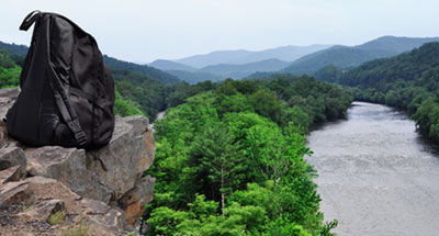
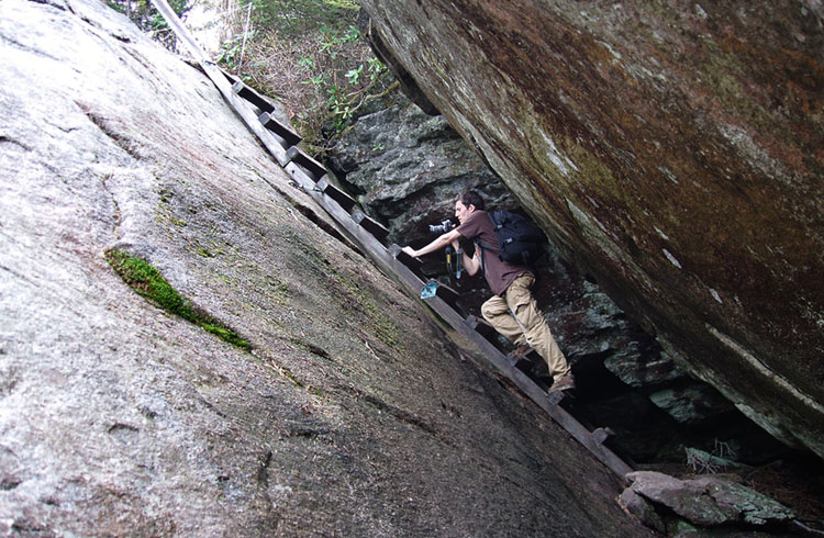
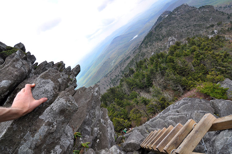
On many occasions the trail is traversed not on two feet but on all fours, climbing long ladders anchored into rocky cliffs that would otherwise require climbing gear or Spider-Man-like powers. Those ladders are a lot of fun. The chutes, on the other hand, well, those should be avoided. Slipping at a treacherous spot could result in a precipitous slide off the mountain and game over, so it's not a trail to be attempted in inclement weather or by novice hikers. As the trailhead itself warns, "this trail is for experienced hikers".Shoes with good traction are a must, and pets should be left at home unless you have a dog carrier backpack.
Although the Grandfather Trail is free to access, entry to the mountain via the Grandfather Mountain Entrance Road is priced at $20 USD per person for ages 13-59, $18 for seniors above the age of 60, $9 for children aged 4-12, and free entry for those less than 4 years of age (as of the time of my visit). One of the curves on this entrance road served as the filming location for a scene in the film Forrest Gump, in which Forrest runs along a curvy mountain road. The location is now named Forrest Gump Curve.
It's possible to access the Grandfather Trail for free if you start from the Profile Trail to the west or the Daniel Boone Scout Trail to the east, but both options add an additional 3+ miles when combined with the full length of the Grandfather Trail, meaning a round-trip total of 11 to 12 miles (17.7 to 19.3 km).
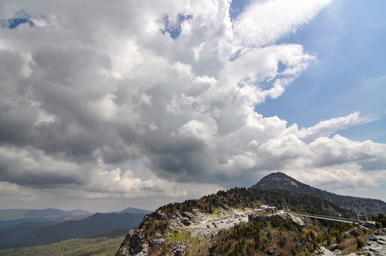
Grandfather Mountain has the distinction of being the highest peak on the main Blue Ridge crest as well as having the highest elevation suspension footbridge in America. The mile-high swinging bridge, as it is called, is a 228-foot (69.5 meters) suspension bridge spanning an 80-foot (24.3 meters) chasm at an elevation of one mile above sea level.

The swinging bridge is accessible from the same parking area as the Grandfather Trail, so a walk across the bridge makes for a good precursor to the hike as well as a decent fear of heights test. The trail, after all, will feature many similar heights.
Across the bridge lies Linville Peak, with its prominent rock bluff affording exceptional views for miles. On a really clear day, views of up to 100 miles (160.9 km) are possible, making even the distant Charlotte city skyline visible.

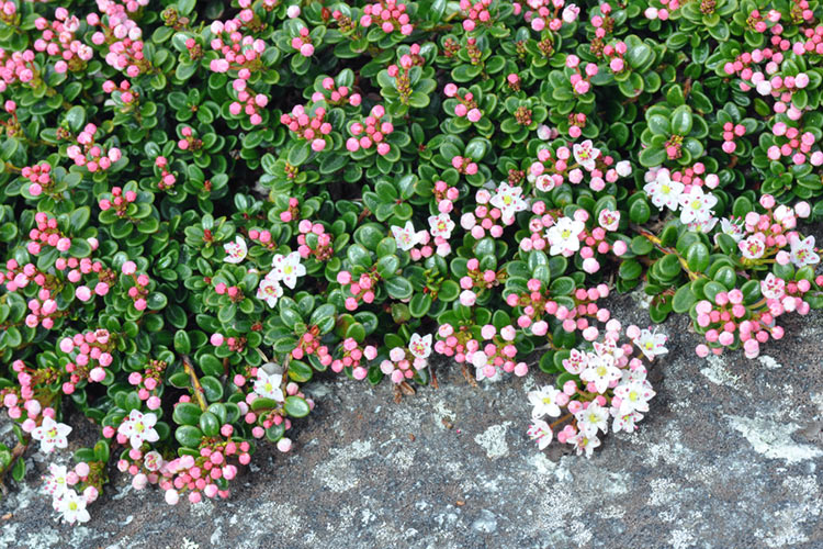
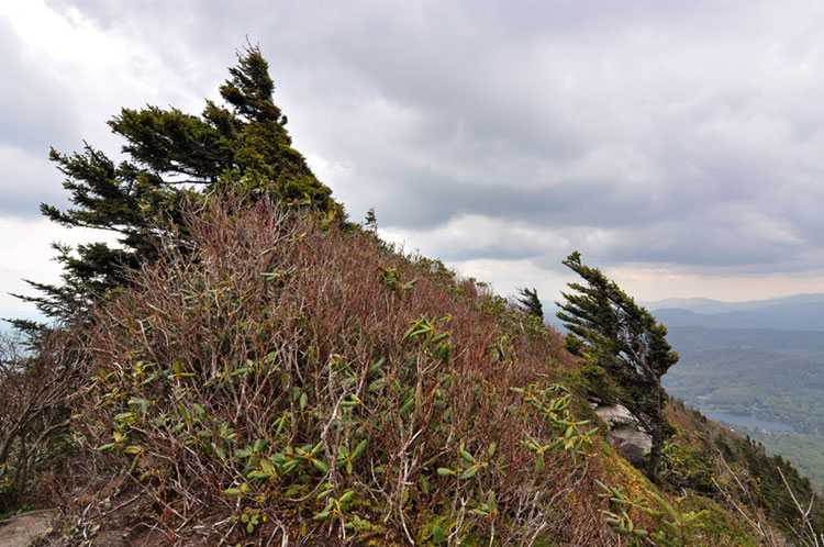
The Grandfather Trail begins at the north side of the parking area next to a large trailhead sign, after which it follows a blue blaze. One of the immediate striking things about the trail is how different the biome is above 5,000 feet. This is an environment where short and stubby is an advantage, and height subjects you to the mercy of the bitter wind and weather. Consequently, the most exposed portions of the mountain are dominated by plants that you might normally only expect to see in a rock garden, such as the sand myrtle. This flowering plant is found natively in only three areas in the eastern United States, one of which is the southeastern Blue Ridge Mountains. It thrives on Grandfather Mountain, with its carpet-like shrubs covering both soil and rock alike. The flowers are tiny, but the sheer volume of them is enough to add white and pink patches to an otherwise green and gray landscape.

The first leg of the trail is relatively easy and welcoming, featuring an open area fittingly called The Patio. First impressions can be deceiving though. This is the same trail that features an outcropping known as Attic Window Peak, and the endpoint at Calloway Peak is a lofty summit that looks like a giant chimney, completing the metaphorical house-trekking journey. Within the first mile, the leisurely walk is quickly encumbered by cable ropes and ladders, culminating in a particularly thrilling series of ladders one after another that scale the cliff to the top of MacRae Peak.
This climb is arguably the most difficult stretch of the trail. While most people will find it enjoyable, some may struggle with the mental challenge of clinging to near-perpendicular ladders at deadly heights. There is, however, an alternative option. Not long before MacRae Peak, the trail splits into two. The Underwood Trail, marked by a yellow blaze, follows a safer and decidedly less exciting route around the peak, joining back up with the Grandfather Trail half a mile later.
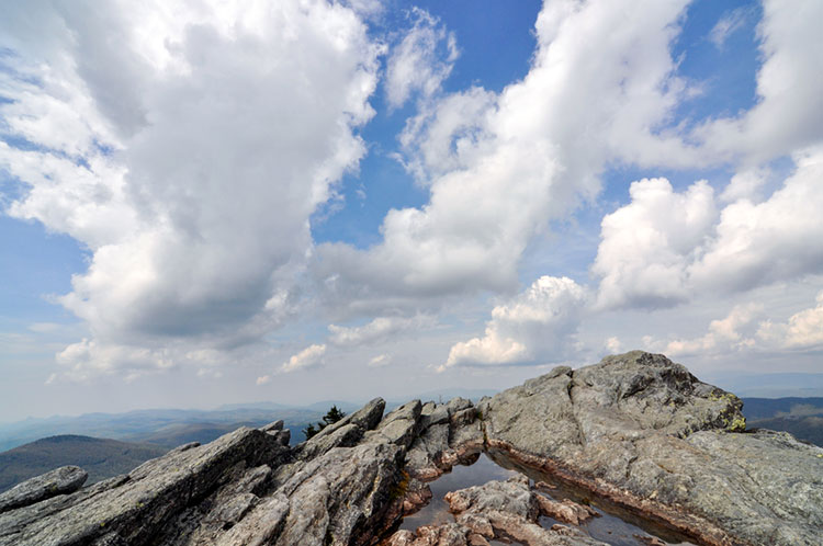
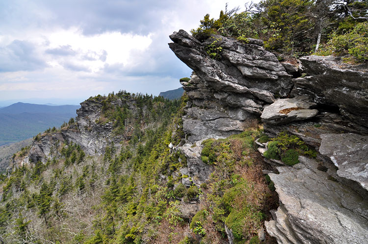
Stepping onto the top of MacRae Peak feels a bit like setting foot in a new world, and you may question if you're still in North Carolina. The mountaintop becomes increasingly exposed, and the vegetation ever more sparse. What started as a walk in the woods becomes a walk above the woods, as trees that are capable of surviving at this elevation become fewer and more dwarfed by the wind. The only forest to be found is a remnant of a southern spruce-fir forest, one of the most endangered ecosystems in the United States. Spruce-fir forests have been ravaged by logging and pollution, as well as by the invasive balsam woolly adelgid from Europe.
The undergrowth, too, takes on a weathered sight, becoming a twisted jumble of shrubs, heath, and rhododendrons sculpted by high winds. At times, the trees and shrubs conform to the shape of the mountain, some permanently bent into submission by the wind, others stunted into bansai-like miniatures or two-faced creations flourishing one healthy side while the other is mangled.
The terrain atop Grandfather Mountain is the most rugged of any hike I've seen in North Carolina. House-sized boulders bear deep clefts as if split by Thor's hammer, and massive slabs of metamorphic rock jut out from cliffs like aircraft wings. It's this broken and uneven profile that earned the mountain its name; different profiles of an old man's face can be observed from multiple vantage points around the area. "Grandfather" is not the only name for the mountain though. The Cherokee knew it as "Tanawha" for many years before pioneers arrived, which roughly translates as great hawk.

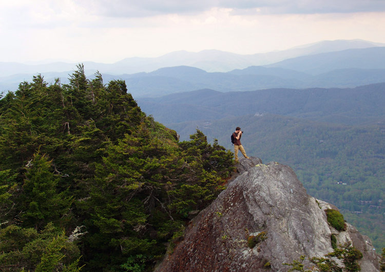
Those who reach the summit of Grandfather Mountain, and the end of the Grandfather Trail at Calloway Peak, will be rewarded with arguably one of the best views in the Appalachian Mountains. It may make you feel a desire to sing and shout, like French botanist and explorer André Michaux, who in the first recorded ascent of the mountain in 1794 wrote in his journal "Reached the summit of the highest mountain in all of North America, and with my companion and guide, sang the Marseillaise and shouted 'Long live America and the Republic of France, long live liberty!'" He was considerably mistaken about the height, however. Grandfather Mountain wouldn't rank within the top 300 nationwide, or even the top 10 east of the Mississippi.
Michaux wasn't the only noteworthy visitor to break into song upon taking in the view. John Muir, founder of the Sierra Club, was so overcome with awe after reaching the summit in 1898 that he supposedly began jumping and singing. In a letter to his wife, he even claimed that the mountain air had healed him of a bronchial cough. He was probably just high on the intoxicating scent of red spruce...
The mountain's early explorers also included Daniel Boone, who is known to have hunted in the area during the 1760's. His name features in the Daniel Boone Scout Trail, which also leads to Calloway Peak after climbing the mountain from the east side.

Doubling back on the trail to return to the parking area comes with a couple options for new scenery. The first one is the Underwood Trail, which avoids MacRae Peak. It's not nearly as exciting, but it does still feature a long ladder. It's also a safer option if the weather should become unexpectedly wet.
The second option is the Grandfather Trail Extension, encountered near the Patio section of the trail. It swings further south to connect with the Bridge Trail, which then passes under the swinging bridge and ends at the south side of the parking area. Returning via the extension will tack on roughly another two-thirds of a mile.